ARUBIA scans any property — vineyards, solar farms, commercial sites, land — from space every few days, and tells you exactly what changed and where to look. Catch issues early, skip the healthy ground.
Get a free scan of your fields How it worksMost growers walk the whole property hoping to spot trouble. ARUBIA points you straight to the zones that changed.
Focus scouting on the priority acres instead of all of them — often more than half the property can wait.
We track every satellite pass, so a declining block gets flagged before it's obvious from the road.
Catching one problem early — a stressed block, encroaching brush, standing water — can be worth far more than a season of monitoring.
Same satellite intelligence, tuned to your industry. The universal question we answer: what changed, and where do you look?
Vine vigor and crop stress — scout the few acres that need it, not all of them.
Vegetation encroachment, standing water, and site changes before they cut output.
What changed on the property — vegetation, lots, drainage — every ~90 days.
Vegetation, water, and change trends for due diligence and buying decisions.
"Here's exactly what changed on your property in the last 90 days."
Vegetation management, stormwater zones, and asset-change monitoring.
No hardware, no drones, no installs. Just your field location.
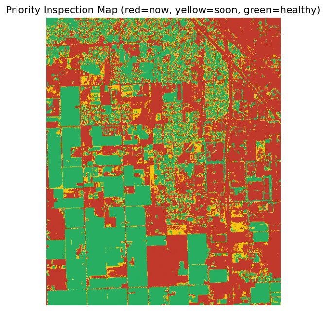
A real ARUBIA scan. Red = inspect now, yellow = soon, green = healthy. Print it, hand it to your crew.

In this sample, just over half the acreage flagged for scouting — the rest could wait. That's the whole idea: your time goes where the problems are.
Decision support, not just imagery — for land, commercial real estate, vineyards, and orchards. Most buyers choose Professional.
⚡ Your report is delivered to your inbox — usually within ~15 minutes of purchase.
Want it kept current? Add ongoing monitoring, per property:
Tell us what you want watched. We'll send back a free satellite scan — no cost, no commitment.